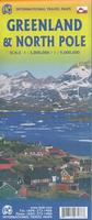
Greenland and the North Pole Travel Map. 1:3,000,000 & 1:9,000,000. ITMB. The front has a good overview map of Greenland. The reverse side has a map of the North Pole, thanks to a marvelous effort by the National Atlas people at Natural Resources Canada, who compiled and prepared the North Pole map as their contribution to the International Scientific Year of the Polar Ice 2009. The map shows boundary, national park boundary, capitals, villages, world heritage site, airport, heliport, ferry and other information.
$12.95
64-6790
1 sheet, folded
$12.95
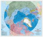
North Circumpolar Region 1:9,000,000. National Resources Canada. This recently revised (2008) bilingual map is part of the Atlas of Canada Reference Map Series. It has detailed coverage of all parts of the world north of approximately 50 degrees latitude except for the Russian Federation side of the map which shows areas north of 60 degrees latitude. The map uses the Azimuthal Equidistant projection. All national boundaries are shown along with Canadian provincial and territorial boundaries and Canada's 200 nautical mile offshore Exclusive Economic Zone. National capital cities are displayed along with other cities, towns, villages and hamlets; all have been updated to 2008. Some seasonally populated places are also shown. A number of significant northern features can be found such as the minimum permanent polar sea ice extent for 1972 to 2007, tree line, undersea relief and undersea feature names, land relief, historical surveyed locations of the Magnetic North Pole from 1831 to 2007 and updated glaciers, ice fields and coastal ice shelves. The undersea relief is the most up-to-date from the 2008 International Bathymetric Chart of the Arctic Ocean on top of which bathymetric tints are shown. Size is 36 x 42 inches.
Image of the entire Arctic Circumpolar map
$19.99
66-19904
2008 edition.
The Arctic and Antarctica Map. 1:10,000,000. British Antarctic Survey #Sheet 1, 2007. This map, prepared for the Internatinoal Polar Year 2007-2008, is a good summary map of both poles. Side one is a topographic map of the Arctic; including bathymetry, elevation, major rivers, lakes and ice. It shows major towns, transport networks, airports and national boundaries. Coverage limits are 90°N - 60°N.
Side two is a topographic map of Antarctica; including bathymetry, elevation, ice/rock limits, ice shelves and scientific research stations. Coverage limits are 90°S - 60°S.
Arctic map sample Image of both sides of the Arctic/Antarctica map
$24.99
66-19496
1 sheet, folded
Canada's Arctic Region Maps. 1:1,750,000. GoTrekkers.
This is the only map series to cover Canada's Arctic Region. Includes place names, latitude/longitude grid, contours lines and more. The three folded maps can be spliced together to give an excellent wall map of the Canadian Arctic.
Canada's Arctic Region, map 2 - West. Covers the western Arctic from 67° to 74° north.
$19.99
64-2874-AR3
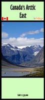
Canada's Arctic Region, map 3 - East. Covers the eastern Arctic from 67° to 74° north.
$19.99
64-2874-AR4
Canada's Arctic Region, map 4 - East. Covers the eastern Arctic from 60° to 67° north.
$19.99
64-2874-AR5
Canada's Arctic Region, map 5 - East. Covers the eastern Arctic from 60° to 67° north.
$19.99
64-2874-AR6
Canada's Arctic Region, map 6 - East. Covers the eastern Arctic from 60° to 67° north.
Canada's Arctic Region Map Series - large scale. 1:1,250,000. GoTrekker.
This series is the same cartography as the series above, but is produced at a larger scale of 1:1,250,000.
This series covers the Arctic regions of Canada - it does not offer circumpolar coverage of the entire arctic.
$29.99
64-2874-ARL-1
Canada's Arctic North map. Covers from 74 degrees north. Folded.
$29.99
64-2874-ARL-2
Canada's Arctic West map. Covers from 67 to 74 degrees. Folded.
$29.99
64-2874-ARL-3
Canada's Arctic East map. Covers from 67 to 74 degrees. Folded.
$29.99
64-2874-ARL-4
Canada's Arctic Southwest map. Covers from 60 to 68 degrees. Folded.
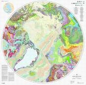
Circumpolar Geologic Map of the Arctic. 1:5,000,000. Geological Survey of Canada Map 2159A. 2011, updated 2013. Trilingual English/French/Russian. An excellent geological map of the arctic region; recommended. Color plot on water- and tear-resistant synthetic paper.
Sample detail from the map thumbnail of the entire map
$34.95
66-1976
1 sheet rolled
Residual Magnetic Anomaly Chart of the Arctic Ocean Region. 1:6,000,000. 1985. Geological Society of America (MC-53). The map is done on a polar stereographic projection with notes and legend in the margin. Data are more plentiful for the non-Soviet portion of the ocean.


 North Circumpolar Region 1:9,000,000. National Resources Canada. This recently revised (2008) bilingual map is part of the Atlas of Canada Reference Map Series. It has detailed coverage of all parts of the world north of approximately 50 degrees latitude except for the Russian Federation side of the map which shows areas north of 60 degrees latitude. The map uses the Azimuthal Equidistant projection. All national boundaries are shown along with Canadian provincial and territorial boundaries and Canada's 200 nautical mile offshore Exclusive Economic Zone. National capital cities are displayed along with other cities, towns, villages and hamlets; all have been updated to 2008. Some seasonally populated places are also shown. A number of significant northern features can be found such as the minimum permanent polar sea ice extent for 1972 to 2007, tree line, undersea relief and undersea feature names, land relief, historical surveyed locations of the Magnetic North Pole from 1831 to 2007 and updated glaciers, ice fields and coastal ice shelves. The undersea relief is the most up-to-date from the 2008 International Bathymetric Chart of the Arctic Ocean on top of which bathymetric tints are shown. Size is 36 x 42 inches.
 Image of the entire Arctic Circumpolar map

 Arctic map sample
 Image of both sides of the Arctic/Antarctica map
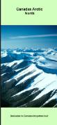
 Circumpolar Geologic Map of the Arctic. 1:5,000,000. Geological Survey of Canada Map 2159A. 2011, updated 2013. Trilingual English/French/Russian. An excellent geological map of the arctic region; recommended. Color plot on water- and tear-resistant synthetic paper.
 Sample detail from the map
 thumbnail of the entire map