Pacific Ocean Region Travel, Wall Maps and Atlases
New title! Polynesian Islands Travel Atlas. 1:3,400,000. ITMB, July 2015. ISBN 9781553412007.
The atlas covers the Cook Islands, Easter Island, Hawaiian Islands, Nauru, Samoa, Solomon Islands, Tahiti/French Polynesia, and Tonga. It is not complete for all of what might be considered Polynesia, in that Vanuatu, Kiribati, Tuvalu, and New Caledonia were left out.
$18.95
66-12169A
Atlas.
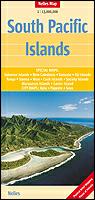
South Pacific Islands Travel Map. 1:13,000,000 + multiple inset maps at larger scales. Nelles Verlag.
This folded travel map has an overview map of the South Pacific region at 1:13,000,000. The reverse side has numerous inset maps each covering an island are a larger, more detailed scale. The maps have the road network overlain on a physical base map.
Sketch map showing coverage of the South Pacific travel map
$13.95
66-1293
1 sheet, folded.
Pacific Ocean. National Geographic Maps. An excellent map of the Pacific Ocean floor and surrounding land masses. The map shows the spreading centers/ridges and subduction zones of the Pacific "rim of fire". With descriptive text in the margin. ISBN 1-57262-179-6. Size 32-3/4" x 21-3/4".
An image of the full map A detail of the map A sample of the legend
$14.95
66-12180
Flat/rolled
$19.95
66-12180L
Laminated
Pacific Ocean Region Geologic and Thematic Maps
Circum-Pacific Region Geodynamic Map. 1:10,000,000. 1984. This six-sheet map is the companion to 66-1220 above. It illustrates free-air gravity contours, earthquake focal mechanisms, seismic epicenters, crustal thicknesses, Holocene volcanics, and active faults. Sheet size 137 x 100 cm.
$19.95
66-1207-NE
Northeast sheet.
Sale price! Map of the Oil and Coal Potential of the Pacific Mobile Belt and the Pacific Ocean. 1:10,000,000. 1979. VNIIzar. Twelve sheets; in Russian.
$99.99
66-1208
Set, rolled
Sale price! Pacific Ocean Energy Resources Map. AAPG. Only the Southeast sheet is still in print.
$7.99
66-1209-SE
Southeast quadrant.
Sale price! Seismicity Map of the SW Pacific. NOAA. 1970. Shows seismic activity for 1962-1969. A black/white map.
$2.99
66-1210
1 sheet, folded
Sale price! Bathymetry of the Northcentral Pacific. 1:6,442,194. 1985. Geological Society of America (MC-52). The map shows detailed bathymetry for the region of 2oS - 46oN and 145oW - 155oW.
$3.99
66-1214
Each, folded
Sale price! Bathymetry of the Northeast Pacific. 1:6,442,194. 1981. Geological Society of America (MC-43). The map shows detailed bathymetry for the region of 4oS - 45oN and 155oW - 77oW (the west coast of North & Central America).
 New title!

 Sketch map showing coverage of the South Pacific travel map
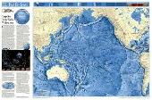
 An image of the full map
 A detail of the map
 A sample of the legend