Sale Items. Priced at 40% or more off retail. This section contains items on sale that are either discontinued items, items we previewed and decided not to stock, or items superceded by a new edition (noted if this is the case). All items are new, not used, and just excess inventory.
NOTE: No rainchecks - prices good on existing stock only. We have typically only one or two copies of each of these sale items in stock. These items are discontinued when sold out.
Wildlife Map of Acadia National Park. 1:50,000. American Nature Maps. 1989.
62-7165
1 sheet, folded
$3.99
Satellite Image Posters on Sale
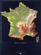
On Sale! France Satellite Image Maps. Scale varies. BRGM. These very colorful Landsat image maps highlight the better-known regions of France. Printed on heavy poster paper, these images make excellent wall displays. Map size varies. In French.
France poster thumbnail image
Street Atlases. Rand McNally & Dolph's. These are new overstock or superceded editions; the publication year is noted for each item.
SALE-46
(CO) Denver street atlas, 2003. Rand McNally.
$12.99
SALE-41
(FL) Charlotte, Lee, & Collier Counties street atlas, 2006. Dolph.
$12.99
SALE-52
(FL) Indian River, St. Lucie, Martin Counties street atlas, 2006. Rand McNally.
$12.99
SALE-44
(FL) Jacksonville street atlas, 2005. Rand McNally.
$9.99
SALE-40
(FL) St. Petersburg street atlas, 2005. Rand McNally.
$9.99
SALE-47
(TX) Austin street atlas, 2003. Rand McNally.
$9.99
SALE-48
(TX) San Antonio street atlas, 2003. Rand McNally.
$9.99
SALE-42
(WA) Snohomish County (Everett) street atlas, 2003. Rand McNally.
$9.99
MapEasy International Destination Maps.
65-4280BG
Bangkok.
$7.95
64-3692TE
Toronto.
$6.95
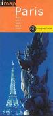
I-Map laminated city-center maps. iMaps are a unique series of laminated city maps, each with a small compass attached to the map. These maps include detailed maps of the main tourist area, a street index, and laminated flip-pages that highlight the main sights to see, places to visit, shopping, restaurants, useful info, and getting around.
Sample from the Paris map.
SALE-26
Sydney.
$4.17
SALE-29
Zurich.
$4.17
International Maps on Sale
Atlas of Australian Resources (Third Series). AUSLIG. This excellent atlas series covers major thematic topics for Australia. Each volume contains a wealth of information and comes complete with one or more 1:5,000,000 map(s) pertaining to the subject of the atlas.
64-1349-3
Vol. 3. Agriculture.
$9.99
64-1349-4
Vol. 4. Climate. 1986.
$9.99
64-1349-5
Vol. 5. Geology & Minerals. 1989.
$19.99
64-1349-6
Vol. 6. Vegetation. 1990.
$19.99
Atlas of Australian People. 1987 (1986 Census). AUSLIG. Contains a variety of information derived from census data for several major cities. We have only the Brisbane volume left in stock.
64-13493-02
Brisbane Volume
$13.99
Guide to the Belgian Rivers. Ludo de Clerq, 1997. A very detailed atlas covering the rivers of Belgium. The black/white or black/blue/white maps include numerous enlargements of docking areas, busy sections of the rivers, radio frequencies for talking with lock masters, etc. Extensive descriptive text for boaters, but not much on-shore tourist information. Softcover, multilingual, including English.
SALE-31
Atlas.
$29.99
Tourist Navigation Guide for West Flanders, East Flanders, Brabant, Brussels, Hainaut, Nord-Pas de Calais. 2000. Very detailed canal & river atlas covering from Brussels to Bruge to Calais. Extensive use of symbols to show facilities for boaters and tourist sites on the river. Spiral-bound, bilingual English/German.
SALE-30
Atlas
$29.99
Series of Environment Geology Map of China. 1:6,000,000. Cartographic Publishing House, 1992. Each comes with a 23-page bi-lingual Explanation booklet as well as a large bi-lingual map. These are an excellent general overview of the geology of China, especially since the maps are in English.
Sample from the Environmental Geology map
64-4003-01
Map of Tourist Geological Resources of China.
$9.99
64-4003-02
Map of Special Soil and its Hazards of China.
$9.99
64-4003-03
Map of Environmental Geology Division of China.
$9.99
64-4003-04
Map of Soil Erosion of China.
$9.99
64-4003-05
Map of Karst Collapse of China.
$9.99
64-4003-06
Map of Desert and Desertification of China.
$9.99
64-4003-07
Map of the Hazards Caused by Groundwater of China.
$9.99
64-4003-08
Map of Debris Flow Hazards of China.
$9.99
64-4003-09
Map of Geological Nature Reserves of China.
$9.99
64-4003-10
Map of Soil Salinization and Swamping of China.
$9.99
64-4003-11
Map of Type and Distribution of Landslides & Rockfalls of China.
$9.99
Polva Maakonna Tourist Map. 1:100,000. E. O. Map. 1993. Covers the southeastern province of Estonia. Bilingual. Now 60% off.
65-7175
1 sheet, folded
$3.00
(Estonia) Governy Historical Map (Generalkarte von Estonia). Reproduction of an 1800's german map. Now 50% off.
65-7180
1 sheet, rolled
$10.00
(Estonia) Virumaa Travel Map. 1:200,000. Regio, 1992. In English. One of the first maps published after independence from Russia. Now 60% off.
65-7192V
Virumaa Region.
$3.00
Estonia 1:250,000 Topographic Map. 1993. Estonia. 4 sheets. In Estonian. Now 75% off.
65-7154
4 sheets, rolled
$10.00
Estonia Waters Map. 1:400,000. Regio. With short text booklet. Now 75% off.
65-7130
1 sheet, rolled
$3.00
Estonian Mires (Eesti Sood) Map. 1:400,000. Regio. 1993. Trilingual. Now 75% off.
65-7135
1 sheet, folded
$3.00
(Finland) Helsinki Atlas (Helsinki-Atlas). 1:60,000. Kaupunkimittausosasto. 1986. This is a thematic map atlas of Helsinki with the maps generally at 1:60,000 scale. The maps include general maps, topographic maps, environmental maps, laand use maps, statistical maps, education & culture maps, and technical (infrastructure) maps. In a 3-ring binder with removeable map pages. In Finnish/Swedish. Price includes a 45% discount.
64-5571
Atlas
$50.00
France Administrative Map. Blay. A single-sheet folded map that shows the administrative boundaries in France. In French.
64-56463
1 sheet, folded
$5.99
50% discount! (France) Hiking Guidebooks by IGN (les Guides IGN). Institut Geographique National. The French government map agency has published several guidebooks to classic hiking and outdoors tourist areas of France. These guides include detailed descriptions of hikes, climbing routes, cross country ski routes, bicycling routes, and much more. The guides include numerous color photographs, map sections, cliff-face sketch maps, and more. In French.
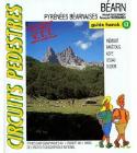
55% discount! Guide Franck Mercier Hiking Guides to France. There are two main types of guides; hiking guides and cycling guides. Each hiking and biking guide offers a generous selection of circuit hikes or ciruit bike rides in the region. Each route information is contained on a single looseleaf sheet, with the map on one side and the description on the reverse. Each guide is looseleaf so that the page for the hike or ride can be removed and carried in the handy plastic carrying pouch. In French.
Hiking Guides (Circuits Pedestres et VTT).
64-56983-10
#10. Beaufortain.
$9.98
64-56983-21
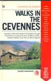
#21. Cevennes.
$9.98
64-56983-28
#28. Monts du Lyonnais.
$9.98
64-56983-44
#44. Orleanais, Sologne.
$9.98
64-56983-46
#46. Balcon du Mont Blanc.
$9.98
64-56983-47
#47. Nievre.
$9.98
64-56983-53
#53. Pyrenees Luchonnaises.
$9.98
64-56983-58
#58. Bordelais-1.
$9.98
64-56983-63
#63. Bearn.
$9.98
64-56983-65
#65. Maconnais-Charolais.
$9.98
64-56983-73
#73. Pays de l'Aisne.
$9.98
64-56983-77
#77. Aude-Sentiers Cathares.
$9.98
64-56983-78
#78. Volcans d'Auvergne - Sancy.
$9.98
Germany Cycling Atlases. Bielefelder Verlag. Spiral-bound atlases with route maps and descriptive text. In German. Size is 5 x 8".
Sale-2
Elberradweg - Magdeburg - Cuxhaven. 157 pages.
$12.97
Sale-3
Emsland. 140 pages.
$11.97
Sale-4
Munsterland. 143 pages.
$11.97
Germany Cycling Atlases. Bielefelder Verlag. Larger spiral-bound atlases with route maps and descriptive text. In German. Size is 9 x 9".
Sale-5
Herkules-Wartburg Radweg. 1:50,000.
$8.97
Sale-6
Rheinradweg. 1:50,000.
$8.97
Sale-7
Rijnfietsroute - Rheinradweg. 1:50,000.
$8.97
Sale-8
RuhrtalRadweg. 1:50,000.
$8.97
On Sale! Greece Hiking Maps. Anavasi. These are maps recently replaced by new editions.
64-6678-08
Agrinio & Kravara region. 1:55,000. 200m contours. 50 x 70 cm. map with 32-page text. In Greek.
$6.99
64-6678-17
Evritania (Central Greece). 1:100,000.
$6.99
64-6678-11
Karpenisi Prousos. 1:50,000. 100m contours. 50 x 85 cm. map with 32-page text with 20 color photographs. In English.
$6.99
64-6678-02
Mt. Parnassos. 1:55,000. 50m contours. 50 x 70 cm. map with 24-page booklet. 58 color photographs. In English.
$6.99
64-6678-05
Mt. Elikon. 1:55,000. 200m contours. 50 x 70 cm. map. In Greek.
$6.99
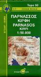
64-6678-06
Mt. Kirfi & Lidoriki Mountains. 1:55,000. 200m contours. 50 x 70 cm. map with 16-page text. In Greek.
$6.99
64-6678-09
Mt. Oeta (Iti). 1:55,000. 100m contours. 50 x 85 cm. map with 32-page text with 20 color photographs. In English.
$6.99
64-6678-10
Mt. Othris. 1:55,000. 200m contours. 50 x 70 cm. map with 30-page text. In Greek.
$6.99
64-6678-27
Zagori. 1:50,000.
$12.95
(Greece) Naxos Tourist Map. 1:50,000. Harms Verlag. A shaded relief map without contour lines but with numerous spot elevations. Includes tourist information and inset maps. With latitude/longitude grid. Multilingual.
Detail of the Naxos map.
64-66770
1 sheet, folded
$6.99
(Greece) Santorini Tourist Map. 1:50,000. Harms Verlag. A small hypsometric map of the island. With latitude and longitude grid.
Detail of the Santorini map.
64-66771
1 sheet, folded
$6.99
Exploratory Soil Map and Agroclimatic Zone Map of Kenya. 1:1,000,000. Kenya Soil Survey, 1980. Includes multi-sheet map and 56-page descriptive text in a slipcase. In English.
SALE-34
Atlas.
$31.99
Netherlands Provincial Topographic Atlases - Current editions. 1:25,000. Topographische Dienst. These atlases include 1:25,000 topographic maps for the appropriate provinces. We are overstocked on these two regions, which we are selling at 35% off. Hardcover, in Dutch.
65-05537-04
Limburg.
$44.99
65-05537-04
Overijssel.
$44.99
Netherlands Provincial Topographic Atlases - Superceded editions. 1:25,000. Topographische Dienst, typically 1998. These atlases include 1:25,000 topographic maps for the appropriate province. These have been superceded by new editions and we are selling these at 1/2 off. In Dutch.
65-05539-AC
Achterhoek.
$29.95
65-05539-BE
Betuwe.
$29.95
65-05539-OV
Overijssel.
$29.95
65-05539-VE
Veluwe.
$29.95
Atlas of Netherlands (Atlas van Nederland). 1984. Topographische Dienst. Twenty-one separate volumes, each approximately 20-25 pages long. We have only five volumes left. Paperback, center-stapled, in Dutch.
65-0548-01
Population (Bevolking). 1984.
$14.99
65-0548-02
History of Inhabitants (Bewoningsgeschiedenis).
$14.99
65-0548-05
Wonen. 1984.
$14.99
65-0548-15
Water. 1986.
$14.99
65-0548-18
Ruimtelijke ordening. 1984.
$14.99
Netherlands Historical Provincial Atlases. These atlases offer historical topographic maps of the Dutch provinces. We have only the single volume listed below. Hardcover, in Dutch.
65-0555-04
Limburg
$33.99
(Romania) The Danube Delta Tourist Map. 1:200,000. Amco Press, Bucuresti. 2000. A double-sided map; the front has a detailed map of the region along with numerous color photographs of tourist sites and detailed tourist paths. The reverse has extensive descriptive text. Bilingual English/Romanian. Size is 70 x 100 cm.
65-23722
1 sheet, folded
$4.00
Atlas of Slovene Towns (Atlas Slovenska Mesta in Naselja). Kod & Kam, 2006. 1:12,500. This atlas contains 120 city street plans and a small road atlas section. The road atlas is indexed; the city maps are not. The population and zip code are given for each city, along with the contact information of the tourist office in each city/town. The city maps use numerous symbols to show locations of tourist sites and services. Softcover, 144 pages. In Slovenian with multilingual legend.
Switzerland Climate Atlas (Klimaatlas der Schweiz/Atlas climatologique de la Suisse). BL. There are now five volumes to the Swiss Climate Atlas; this set includes only volumes 1, 2, 3 (1982, 1984, 1987). The more recent volumes are available by special order.
65-3935
Set of 5 volumes
$99.99
Uruguay Political Wall Map. 1:500,000. 1992. SGM. A detailed political wall map, spliced, mounted on linen, with wooden rods top and bottom. In Spanish.
65-50537W
Wall map.
$31.99
50% discount! Footpaths of Europe hiking guidebook series. Robertson McCarta & Grande Randonnée. This series of guidebooks is derived from the excellent series of french-language hiking guides published by the FFRP, the French long-distance hiking organization. These guides are condensed from several FFRP guides and then translated into English.
Although most of the guides are about 15 years old, the basic information is still accurate and well worth having in English rather than in French (for those non-French speakers).
64-56982PB
Paris to Boulogne. 1990. A guide to 880 kilometers of footpaths through the historic countryside of northern France, Picardy, and the Tour du Boulonnais. Covers the GR121A, GR121, GR124, GR123, and the GR120, through Arras, Picardy, Hesdin, Crécy, Tour de Ternois, and Tour du Boulonnais.
$9.98
64-56982VO
Walking the GR5: Vosges to Jura. 1990. A guide to 550 kilometers of footpaths through an area of scenic grandeur, abundant forests and superb architecture. Covers Wissembourg, Saverne, Belfort, Fesches-le-Châtel, Pontarlier, Nyon, Tour Pays de Montbéliard.
$9.98
Zambia Physical Map. A good quality color physical/hypsometric map of Zambia. Unfortunately the NE sheet is out of print and only 3 sheets can be supplied (NW, SE, SW).
65-5849
3 sheets, rolled.
$10.00
Zambia National Atlas Series. Survey Department, Zambia. The National Atlas is a loose-leaf atlas first produced in the late 1960's. Some sheets were issued as new editions in the late 1980's. We have limited stock of the sheets listed below and no new stock is expected.
New Series. 1:3,000,000. 1986-.
65-5848-04
Population Growth. Sheet #4. 1986.
$10.00
65-5848-17A
July Mean Temperature. Sheet 17A. 1987.
$10.00
65-5848-26
Educational Facilities. Sheet 26. 1987.
$10.00
65-5848-32
Copperbelt Province. Sheet 32. 1987.
$10.00
Old Series. 1:2,500,000. 1966-1976.
65-5848-02
Central African Communication. Sheet 2. 1966.
$10.00
65-5848-17
Annual Temperature Range. Sheet 17. 1976.
$10.00
65-5848-18
Relative Humidity. Sheet 18. 1968.
$10.00
65-5848-19
Sunshine. Sheet 19. 1967.
$10.00
Zambia City Maps. 1984-1989. Survey Department, Zambia. These are good quality color street maps without indexes.
65-5892CI
Chingola. 1:15,000.
$14.95
65-5892KI
Kitwe. 1:15,000.
$14.95
65-5892M
Mufulira. 1:10,000.
$14.95
65-5892N
Ndola. 1;15,000.
$14.95
50% discount! British Admiralty Nautical Charts. The charts listed below are offered at more than 1/2 off the retail price, while inventory lasts. No rainchecks.
BA-0011
BA-0011 Jazireh-ye Khark and Approaches. 1:75,000.
$44.99
BA-0233
BA-0233 Suez Canal (Qanat el Suweis). 1:60,000.
$44.99
BA-0255
BA-0255 Eastern Approaches to Jamaica. 1:200,000.
$44.99
BA-0260
BA-0260 Pedro Bank to the South Coast of Jamaica. 1:200,000.
$44.99
BA-0843
BA-0843 Approaches to Bass Harbour. 1:50,000.
$44.99
BA-0905
BA-0905 Randers Fjord. 1:30,000.
$44.99
BA-1050
BA-1050 San Jose to Puerto Angel. 1:720,000.
$44.99
BA-1250
BA-1250 Miadao Qundao to Tianjin Xingang. 1:300,000.
$44.99
BA-1602
BA-1602 Outer Approaches to Shanghai. 1:130,000.
$44.99
BA-1797
BA-1797 Monkey River to Colson Point. 1:125,000.
$44.99
BA-2092
BA-2092 Toe Head to Old Head of Kinsale. 1:50,000.
$44.99
BA-2429
BA-2429 Canakkale Bogazi (The Dardanelles). 1:75,000.
$44.99
BA-2523
BA-2523 Cable Bank to Ra's Rakan. 1:150,000.
$44.99
BA-2932
BA-2932 Cabo de Sao Sebastiao to Beira. 1:300,000.
$44.99
BA-3244
BA-3244 Eastern Timor and Pulau Pulau Sermata Western Portion. 1:500,000.
$44.99
BA-3928
BA-3928 Approaches to Mokp'o. 1:100,000.
$44.99
BA-4200
BA-4200 Rio de la Plata to Cabo de Hornos. 1:3,500,000.

 On Sale!
 France poster thumbnail image
 Sample from the Nazareth map
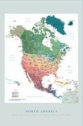
 Thumbnail image of the North America poster
 Detail image of the North America poster
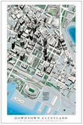
 Thumbnail image of the Cleveland poster
 Detail image of the Cleveland poster
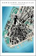
 Thumbnail of Manhattan
 Detail image of Manhattan
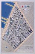
 Thumbnail of Tribeca
 Detail image of Tribeca - large file
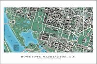
 Thumbnail of the Washington D.C. poster
 Detail image of the Washington D.C. poster
 Sample from the Paris map.
 Sample from the Environmental Geology map
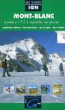 50% discount!
 55% discount!
 On Sale!
 Detail of the Naxos map.
 Detail of the Santorini map.
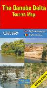

 50% discount!