British Virgin Islands Road Map & Guide. Variable scales. Skyviews. 18th ed., 2010/2011. The map is a pocket tourist map, not a topographic or detailed physical map, but it is excellent at what it does. The map has a map of the British Virgin Islands on the front with larger maps of Virgin Gorda, Jost Van Dyke, and Anegada. The reverse has a larger map of Tortola and an inset map of Road Town. Tourist information specific to each map is included in the margins of each inset map. This laminated map is ideal as a souvenir placemat. Size is 24 x 18 inches.
Sample detail from the British Virgin Islands road map.
British Virgin Islands Travel Map. 1:63,360. British Ordnance Survey, DOS 446. 1991. A single-sided map with inset maps of major cities. Size is 20 x 28 inches.
Thumbnail of the map. Detail from the map.
$9.95
66-3398
1 sheet, folded
British Virgin Islands Base Map. 1:200,000. British Ordnance Survey, DOS 997. 1988 3rd ed. A small color base map of the B.V.I. Size is 10 x 14 inches.
$4.95
66-33981
1 sheet, folded
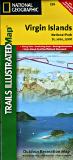
Virgin Islands Topographic Maps
British Virgin Islands Topographic Quadrangle Maps. 1:25,000. DOS (346 & 346P). 1977-1984. Total coverage in 6 sheets; 2 of which are out of print.
 Waterproof!
 Thumbnail of the front of the US Virgin Islands map.
 Thumbnail of the reverse of the US Virgin Islands map.
 Sample detail of the US Virgin Islands map.
 Sample detail of the US Virgin Islands map.
 Waterproof!
 Thumbnail of the front of the US Virgin Islands map.
 Thumbnail of the reverse of the US Virgin Islands map.
 Sample detail of the US Virgin Islands map.
 Sample detail of the US Virgin Islands map.
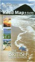
 Sample detail from the British Virgin Islands road map.
 Waterproof!
 Thumbnail of the front of the map.
 Thumbnail of the reverse of the map.
 Sample of the map detail.
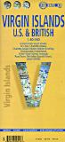 Recommended!
 Sample of the detail of the map.
 Thumbnail of the front of the map.
 Thumbnail of the reverse of the map.
 Recommended!
 Sample of the detail of the map.
 Thumbnail of the map.
 Detail from the map.
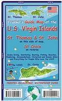
 St. Croix index map
 St. John & St. Thomas index map