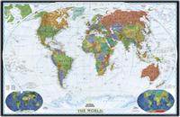
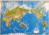
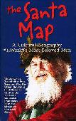
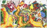
World Terrorism - a reference map. 1:41,000,000. Maplink, 2002. This world map locates hundreds of terrorist incidents around the world from 1967 to the present. The front has a world map showing the locations of each terrorist incident, with date and brief description. The reverse lists all of the incidents in chronologic order.
Detail of the map.
67-2103
1 sheet, folded
$9.95
World Risk Map. No scale. Pinkerton Global Intelligence Service & Maplink, 1999. This map shows the level of risk around the world, as calculated by Pinkerton's. The map also shows health risks and offers basic travel security tips. The reverse side lists the locations of all foreign embassies in the USA, their country's risk level, and any special passport or visa requirements.
Detail of the map.
67-2104
1 sheet, folded
$8.95
Recommended World Heritage Map. 1:40,000,000. Maplink, 2001. This is the first complete summary map of the locations of the United Nation's World Heritage Sites. The front side has a world map showing the locations of over 600 sites, numbered and color-coded into five categories; Endangered, natural sites, cultural sites, historic towns/cities, and mixed sites. The reverse has descriptive text on each site.
Detail of the map.
67-2101
1 sheet, folded
$8.95
(World) Astronomical Observatories and Planetariums of the World. No scale. Maplink, 2001. This map shows the locations, and gives information on, each planetarium or astronomical observatory in the world. The front side has a world map with each site noted and categorized. The reverse has contact information on each site.
Detail of the map.
67-2100
1 sheet, folded
$9.95
(World) The Santa Map. Hedberg Maps. Your family will love tracing Santa's travels across time and continents with this giant fold-out map.
The Santa Map surveys the magic of the eternal winter visitor, unraveling the mystery - and the history - of old St. Nick.
One side includes a history of Santa in all his names and guises. The other side has a world map with numerous notes on how countries celebrate Christmas around the world.
67-2105
1 sheet, folded
$9.95
World Geologic Map. Open University, U.K. An excellent single-sheet geologic map of the world. Less detailed, and less expensive, than the map above, this map is ideal for classrooms, laboratories, or meeting rooms.
Thumbnail of the entire map Legend of the map
67-10015
1 sheet, rolled
$9.95
67-10015-10
10 copies, rolled - Save 25%!
$74.65
67-10015L
Laminated
$32.95
World Atlases
World Atlas (Atlas Mira). Federal Service of Geodesy and Cartography of Russia (3rd edition), 1999. This atlas is one of the most detailed atlases that we have seen and the previous editions were heavily sought after for their information and accuracy.
The cartography is superb and the quality of printing is excellent. The atlas contains 278 map pages, 52 pages of space images, 200 pages of geographical names index (over 250,000 names), and 28 pages of general information. Hardbound, in English.
An atlas that deserves a spot in any major collection.
61-0600
World Atlas.
$499.95
Clearance sale! World Atlas of Resources and Environment (Prioda i resursy Zemii). RAN, Vienna, 1998. This excellent atlas contains two volumes, divided into four major sections; I: The Earth and Space; II: Evolution of the Landscape Sphere; III: Landscape Sphere - Structure and Resources; IV: Anthropogenic Factors of Landscape Sphere Changes.
There are 190 thematic maps (1:6,000,000 to 1:300,000,000), many of which are fold-out maps. Each map sheet has comments on the reverse as well as graphs, tables, etc. In English with Russian titles. Size is 35 x 49 cm, clothbound with screws and slipcase.
61-0800
Atlas.
$49.95
Cities of the World: A History in Maps. The British Library, 2005. Condensing centuries of history in one volume, Cities of the World is a though-provoking and unique book for the armchair traveller, or indeed anyone passionate about the history of human civilization. From Athens to Brasilia, Washington to Moscow, San Francisco to Saigon, or Venice to Lhasa, Cities of the World is a journey via maps, exploring man's perennial love-hate relationship with his finest, most complex and troubling creation, the city. (From the cover).
67-2001
Atlas.
$45.95
World Topographic Maps
World Topographic Map Set. 1:2,500,000. 1965-1972. These topographic maps were published by the USSR and five eastern block countries: Hungary, Czechoslovakia, Poland, Rumania, and East Germany. Compete coverage is available in 234 sheets. Each sheet shows elevation with contour lines and color coding. Each sheet covers an area of approx. 800 x 800 miles. The sheets are in English and Russian. These maps show excellent detail, and yet cover enough area to be useful in the classroom.
67-1054
Per sheet, specify area
$3.95
67-1054S
Set of 234 sheets
$702.00
World Aeronautical Charts, TPC series - click here. 1:500,000. DMA. This series covers Europe, USSR, Asia, and parts of Africa. It is the best coverage available for Asia, USSR, and the Middle East. Click on the link to the left to see index maps and itemized listings.
World Surface Relief Map. 1:39,000,000. 1985. NOAA. This award-winning map is a computer-generated rendition of the surface relief of the world. The first sheet is a Mercator projection showing topography by color-coding. The second sheet is a shaded relief map of the world. The third sheet shows six hemispheric views of the Earth.
67-1075
3 sheets, rolled
$42.00
World Geologic Maps
World Geologic Map. 1:25,000,000. CGMW, Paris, 2000. A more detailed world geologic map than the Open University map listed elsewhere on our web site. More applicable to university and research insititutions and practicing geologists. This second edition has been entirely revised in order to show a clear distinction between sedimentary, volcanic extrusive, and endogenous dated formations. The geology of the oceans has been
updated according to the most recent magnetic and satellite-gravimetric data. Positions of the main volcanoes and meteoritic craters were added to the map. The new cartographic conception of the map allows a rapid visual reconstruction of the main plates and subplates of the global tectonics. Available in three versions; paper, Arc Info® cd-rom (for professional users), or GeoKiosk® cd-rom (for non-professional users). The GeoKiosk version is now out of print and available only as long as our supplies last. Assembled size is 196 x 100 cm (approx. 77 x 39").
Thumbnail of the map. Sample detail of the map.
67-1001
3 sheets, rolled
$55.00
67-1001A
ArcInfo format®
$234.95
67-1001G
GeoKiosk®. While supplies last.
$70.00
67-1001C
GeoKiosk® + printed map. Note: Does not run on Windows XP.
$99.95
World Geologic Map. Open University, U.K. An excellent single-sheet geologic map of the world. Less detailed, and less expensive, than the map above, this map is ideal for classrooms, laboratories, or meeting rooms.
Thumbnail of the entire map Legend of the map
67-10015
1 sheet, rolled
$9.95
67-10015-10
10 copies, rolled - Save 25%!
$74.65
67-10015L
Laminated
$32.95
World--Sedimentary Provinces Map. AAPG. 1984. Shows sedimentary accumulations more than 1000 meters thick. With 36-page booklet.
67-1006
Set
$29.95
World Environments During the Last Two Climatic Extremes. 1:50,000,000. CGMW. 3rd ed., 2006. Two maps. Map 1 is the Last Glacial Maximum (ca 18,000 yrs. B.P.) and Map 2 is the Holocene Optimum (ca 8,000 yrs. B.P.).
The time slices considered in this work correspond to average temperatures of the surface of the Earth 4.5C lower and 2C higher than present temperatures. This is the first time that a reconstruction of the environment is made
using multidisciplinary data of the recent Quaternary. This preliminary attempt provides a serious base for ongoing reflections about the planet's warming due to the increase of the greenhouse effect caused by human activities, and that can be usefully compared
to existing modelisations. Available in either a paper edition or an ArcView digital edition.
Sample detail of the map.
World Soils Atlas & Maps. 1:5,000,000. 1981. UNESCO. A must for all pedologists. Nineteen sheets in ten volumes illustrate the soil characteristics worldwide. Each volume comes complete with extensive text; 6 volumes in French + 4 volumes in English. This set is now out of print. We have a few individual volumes left.
67-10301
Each volume
$50.00
World Coconuts and Oil Palms: World Production and Consumption. 1:40,000,000. OSD (3275). 1992.
67-1065
1 sheet, rolled
$18.95
Mineral Atlas of the World - sheet 9: Europe and Neighboring Countries. 1:10,000,000. CGMW/NGU co-publication, 2000. This is the first published sheet of a series entitled Mineral Atlas of the World that follows the same map assemblage pattern as the Geological Atlas of the World. This sheet covers the area comprised between the Atlantic Ocean to the Urals,
the Near East and part of North Africa included, depicts mineral deposits of about 50 countries, and identifies 760 mineral deposits, a list of which is given on the left side of the map. Bilingual French/English, sheet size 96 x 60 cm.
67-10401-09
1 sheet, rolled
$52.95
67-10401-09D
Digital version.
$40.00
Peri-Tethys Paleogeographical Atlas. 1:20,000,000 (at Equator). CGMW, 2000. This Atlas presents a findings of the Peri-Tethys program, a 5-year project involving about 250 scientists from 30 countries. The program focuses on the influence of the Tethys Sea evolution on the bordering cratons. This work embraces 300 Ma of the Tethyan evolution:
break-up of Pangea, formation and extension of oceanic seaways, and extinction brought about by the collision between the main bordering plates which led to tectonic inversions within the peicratonic basins. In English, 24 maps, plus 300 pp of explanatory notes.
67-10252
Atlas
$300.00
Atlas of Tethys Paleoenvironmental Maps. 1:20,000,000 (at Equator). CGMW, 1993. This Atlas presents a kinematic reconstruction of Tethyan plates and microplates from Permian to Late Miocene times, with a palaeolatitude grid. In English, 14 maps with 305 pp of explanatory notes.